July 2013 – Volume 15, Issue 11: Martha’s Vineyard, Buzzards Bay and Boston
IN THIS ISSUE
Flanigan’s Eco-Logic
Wind Turbines of Cape Cod
Sailing Woods Hole
Composting and Contamination
The Charles River Locks
Recycling at Harvard
The Energy Sage
Touring Boston Harbor

Flanigan’s Eco-Logic: The Vineyard Retreat
There’s nothing like it.
On the deck of the ferry. Cars loaded. The massive engines rev up, a blast of dirty diesel out the stacks, the ferry shudders, the fog horn blows, and we’re off. The ferry does it as it has for years… sliding out of the Woods Hole harbor, past the Nobska Lighthouse, and across Vineyard Sound to Martha’s Vineyard, the land amid the streams. You can feel the mainland, all the worries, shedding, slipping away….
Terry and I are on deck, at the bow, part of an excited summer crowd. The Steamship Authority moved 1,645,570 passengers and 395,480 cars last year on this route. This morning, the sea air is crisp, the wind whipping through us, a cleansing. We pass sailboats of all kinds, sport fishermen. Gull’s fly playfully, earning bread from passengers snapping photos. Seven miles and there’s just enough time to unwind, to shift into low gear.
As the island draws nearer, I look desperately for my grandparent’s home, its weather-beaten shingles and white trim. My grandparents came here every summer. They had a converted fishing boat for overnight “camping” in the Elizabethan Islands. I remember outings to Cuttyhunk, Tarpaulin Cove on Naushon, an epic crossing of the middle grounds in a deep fog. Visiting was fun despite the mandatory swim before breakfast. My grandparents used to hang a white sheet from the attic window to welcome us as we came in on the ferry. I can see it all now like I saw it then.
We come into Vineyard Haven Harbor to disembark. Martha’s Vineyard is the 58th largest island in the United States, third largest on East Coast, and the largest on the East Coast not connected by a bridge or tunnel. It is accessible only by boat and air. It is a triangular island 87 square miles in size, 25 miles east to west. You can get from one tip to the other in about 45 minutes depending on traffic. It’s gorgeous, ravaged by weather and high seas, but sheltered from the hustle of the mainland.
We visit Mom in West Chop, a summer colony that’s frozen in time, a retreat indeed. The old tennis club is on a bluff with piers for swimming. The flagpole is a promontory overlooking the “chop” and Cape Cod beyond. Homes have views of the busy yachting channel into Vineyard Haven. A getaway: rustic, classy, somewhat austere. We’re warmly welcome; the pace slows. I swim both mornings before breakfast. Later, we amble along the rocky beach, skipping rocks and watching the boats go by. The pier at 4:00 is a hit, diving into the clean and cool waters. I talk clean energy. We have dinner “up-island” with family in Chilmark.
Years ago the Vineyard was inhabited by the Wampanoag. The tribe reached a maximum population of 3,000 in the 1600s, then declined to ~300 by the 1760s. The island was known as Noepe, defined as “the land amid the streams.” Just off “the chop” it’s easy to see where the currents collide. Sweeping southwest, one can see “the middle grounds,” where the sea is shallow and the fishing is good. “Big pier” was badly damaged by Sandy, so we check out its new pilings and decking.
No one knows for sure who “Martha” was and for whom the island was named. Some say it was the wife of explorer Bartholomew Gosnold who sailed to the island in 1602, and whose wife and daughter were Marthas. The island was known for its wild grapes… thus the Vineyard. In the 19th century, whaling brought the island and neighboring Nantucket prosperity, ships dispatched worldwide to catch whales and harvest their blubber for lamp oil. That collapsed in 1870 when oil was discovered in Pennsylvania. Commercial fishing out of Menemsha is still viable. The island and lobsters go together.
Today Martha’s Vineyard has a year-round population of 15,000; it swells to 125,000 in summer. Idyllic on this summer day; views of harbors dotted with sailboats; bicycles and beach-goers abound. We head to Aquinnah, crossing over its dunes to its majestic stretches of surf. We lap up the raw energy of the sea and play in the ocean. Hummus on Catherine’s freshly made bread was a hit.
A short, meaningful retreat, and we steam out of Vineyard Haven. To starboard and at berth is the mighty Shenandoah – the ship whose black dog is now a branded clothing line. So quickly the island slips away. Someday soon we’ll be back to enjoy this again.
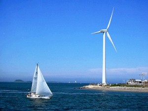
The Wind Turbines of Cape Cod
 The Cape and the Islands are windy places, perfect for wind energy production. For years, the big news has been Cape Wind and its controversial 130-turbine offshore project, slated to be America’s first. Governor Deval Patrick has a goal of 2,000 MW of wind capacity by 2020, drawing from the state’s 6,000 MW offshore wind potential. Wind is expected to be a key renewable component in adhering to the Massachusetts Global Warming Solutions Act. It commits to reducing statewide emissions by 80% from 1990 levels by 2050.
Meanwhile, there seems to be a healthy decentralized movement. Big turbines have sprouted like sunflowers, visible for miles given the flat topography. From the Bourne Bridge we see turbines. On Martha’s Vineyard, a farmer installed a turbine to the chagrin of some neighbors. It was his right to do so despite its prominence on the skyline.
The Air Force has installed several turbines at its Cape Cod Air Force Station, following a plan for 50% of its power to be supplied by the wind. Two new 1.6 MW units are being installed; two are already in place. The new turbines will help power the PAVE Phase Array Warning System used to detect and track sea-launched intercontinental ballistic missiles.
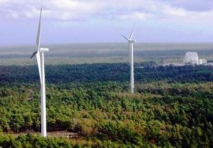
Cape Cod Air Force Station
The Woods Hole Research Center has a 156-foot high, 100 kW turbine. Its total cost was $550,000, offset by a $225,000 grant from the Massachusetts Technology Collaborative Renewable Energy Trust. The Massachusetts Maritime Academy features a Vestas 47 with a 242-foot height and a 660 kW capacity. The turbine cost $1.48 million minus a $500,000 grant from the Collaborative. Some flicker in winter drew complaints from a nearby school, resulting in an agreement to shut down the turbine for key sporting events.
Up the coast are two, 402 foot tall wind turbines owned by the Town of Falmouth. The 1.65 MW, Vestas 82 turbines located at the town’s sewage treatment plant (and a tech park), are the tallest in Massachusetts. The cost for each turbine was $4.3 million, with ~$3 million paid through the grants, and sales of renewable energy credits. Now the Town is considering taking them down. Some neighbors complain that they sound like a boot in the dryer.
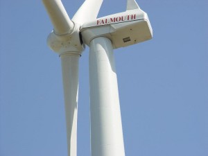
One of the controversial turbines in Falmouth
Despite nearly $10 million in total cost to erect the turbines, and what Town officials call “a thorough vetting process,” the Town’s selectmen are in favor of taking the turbines down at a cost of $14 million. Why? Fully 40 neighbors have complained about health effects, from suffering headaches, to dizziness, and sleep deprivation. A town meeting vote next week will decide whether to ratify the selectmen’s opinion, and tax themselves ~$800 per household over 20 years. In the meantime, the turbines are operating on limited schedules, from 7 AM – 7 PM daily, a financial loss for the community.
Sailing Woods Hole
Sailing out of Woods Hole
Woods Hole is a picture-perfect harbor at the Southwest tip of Cape Cod. It’s all about the sea and ships. Physically and by census, it is an area of 3.9 square miles, although about 40% of this is water. In 2010 it was home to 925 individuals in 450 households. We stay with Meigs in their family home, affectionately known as Windy. A multigenerational retreat it is; a perfect location with shorefront swimming and a marina across the street. The 35-foot Pearson is at the ready.
Years ago, Woods Hole was a center for whaling, shipping, and fishing. Now its residents are a mix of Nobel Laureates and fishermen. Woods Hole is known for marine science institutions: the Woods Hole Oceanographic Institute, Marine Biological Laboratory, Woods Hole Research Center, NOAA’s Northeast Fisheries Science Center, USGS Coastal and Marine Geological Center, and Sea Education Association. Woods Hole also has a Coast Guard station and is a terminus for the Cape Cod – Martha’s Vineyard Steamship Authority.
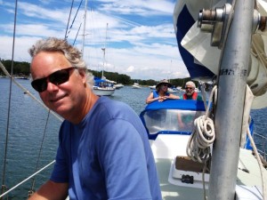
A blustery day. Dinghy to the boat for early morning preparations. We motor to the dock, pick up our crew and lunch, and set sail in the harbor. So quickly we’re out of the shelter of the marina. Awesome is the strength of the currents passing through this “hole.” It’s one of the four straits in the Elizabethan Island chain between Buzzards Bay and the Vineyard Sound. Currents reach six knots. Today, our good ship becomes part of the dance of ferries and vessels of all kinds in this narrow passage complete with treacherous shoals and currents. Jono has everything under control.
He takes us west and into Buzzards Bay, a sea of white caps. As we pass the point, the wind whips our sails. The boat heels dramatically; we’re bracing against the full fury of the sound. The seasoned Pearson pounds through the sea, water splashing over the rails, we tack and winches whirl. We then run with the wind, the main far out, jibe-ho! Then shelter, Hadley Harbor for lunch and swimming. It’s as peaceful as the bay is wild. We have egg salad sandwiches and V8 and dive into refreshing waters, treading, and drawing in the cool of the divine waters.
Composting and Contamination
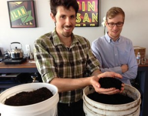
Everett Hoffman and his amazing compost
EcoMotion has formed, spearheaded, and now manages the Cambridge Sustainability Collaborative and its biweekly meetings at the Cambridge Innovation Center. Facilitated by my daughter Sierra, it’s become popular for networking and learning with invited speakers scheduled for months to come.
This week, Everett Hoffman presented his experiences and views on urban composting. There’s an interesting group present… two from MIT, one from BU, one of the owners of the CIC, some interested residents, a reporter. Everett begins by telling his story and how he was shocked by the amount of construction debris at a job site. That led to looking at food wastes and the enormous and untapped potential for composting. He began in this endeavor by collecting tubs of food scraps in his own car. He’s now taken it to scale with City Soil.
The new Sustainability Coordinator for Emerson College arrives, Eric Van Vlandren. His great knowledge and experience from his tenure at the Intervale composting facility in Burlington, Vermont adds to the conversation. While much detail was complex, Eric and Everett concurred that the bottom line is clear: Turning wastes into safe compost is no small feat. Contamination can plague operations.
We learn about polycyclic aromatic hydrocarbons (PAH) and which labs test for them. They are a class of now-regulated systemic herbicides. Since they don’t breakdown, they build up in composting operations.
“Persistent herbicides” plagued Green Mountain Compost (GMC), formerly Intervale Compost Products. This class of systemic herbicides are used to control a wide variety of broadleaf weeds. Clopyralid is most common and made by Dow; another is Aminopyralid. They’re applied to horse pastures, hay fields, golf courses, and lawns, formulated to survive multiple years of exposure.
In June of 2012, GMC began to get alarming calls. By October, 505 cases of vegetable gardens using GMC compost showed signs of duress. Testing revealed persistent herbicides at levels that cause notable wilting of leaves, though reportedly not toxic to humans. Nevertheless, the operator of the Green Mountain Compost, Chittenden Solid Waste District (CSWD), suspended all sales for 2013. CSWD is working to eradicate these regulated compounds from use in Vermont.
The Charles River Locks
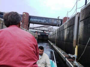
Floating through the locks
Jay Baldwin has the Whaler stocked. He’s come up river to pick us up in Cambridge, at the Broad Canal Boat Landing, just a block from the CIC. The crew brings good cheer. I have the pleasure of meeting Tom Meyer.
Fortunately, the weather is on our side. It looked like rain all day. And like magic, over the transom and it’s calm on the water, despite being surrounded by the drum of the city. We pass neatly under Memorial Drive – ducking our heads under the rusting bridges. Jay opens the throttle up near Longfellow Bridge, we arc east, and head to the locks.
I had no idea that the Charles had locks, but the current ones have been there since 1978 for flood control purposes. (An earlier, now defunct lock dates back to 1912.) The Charles River Dam, or the Gridley Dam as it was originally known, is actually three sets of locks, just downstream of the iconic Leonard P. Zakim Bridge. At the river level, we wait until the red light of the lock turns green, then Jay nurses the boat forward as the locks open. We enter and the water rises, and the outer gate releases us to the harbor.
We pass the U.S.S. Constitution, then head south past the Boston Sailing Club, the mega-boat marina, then the redeveloped and now trendy Long Wharf, Central Wharf, and Rowe’s Wharf. We tie up for dinner.
Recycling at Harvard

Harvard’s Rob Gogan stands in front of Mt. Trashmor
Rob Gogan and I meet for coffee at Pete’s at Harvard Square. He’s enthusiastic about his recent time at the annual Clearwater Revival. We talk about Pete Seeger and his Hudson River legacy. I’m in. Later Rob tells me about City Jam, a non-profit initiative to harvest unused fruit in town. The group turns the fruit to jam, giving a share back to the landowner and selling the rest to continue its mission. Rob’s a key player at Harvard Recycling, a division of Harvard University Facilities, Maintenance, and Operations.
Imagine the huge campus and its constant drum of wastes. Harvard has lots of systems and initiatives for recycling. It’s part of the IRN Network. There’s e-waste, a four-leaf labeling system, and reusable take-out box initiative. Rob manages the redistribution of surplus equipment among departments. An obsolete bookshelf, desk, a computer… To the greatest extent possible, these are repurposed at Harvard, and if need be “sold” locally to keep these materials out of landfills.
Repurposing is a puzzle, laced with timing challenges: Imagine this: Its year-end and Harvard students are moving out of the dorms. Vast quantities of couches, dressers, desks, lamps, food, and clothing are about to hit the curb. The question is how to collect and redistribute it effectively? Rob and his colleagues make sure food gets to food banks, clothes to donation centers, and they continue to work on making sure that bulky items are “rediscovered” and put back in use.
Now Harvard is establishing a warehouse for used stuff. Everything will be catalogued and posted on line. Materials are then “sold,” with a first offering to Harvard departments, then the greater Harvard community, and ultimately externally. The price represents only what you pay the University for delivery. It’s free if you take it away yourself.
I ask about fixing things, remembering a recycling plant in Omiya, Japan that I visited where bicycles, furniture, and other durables are repaired and restored. Harvard’s been working on that. Rob speaks to the remarkable success he’s had in this area in collaboration with workforce development. He’s been impressed by the ability of some of the kids he’s hired with learning disabilities to repurpose electronics, sorting parts with great accuracy, some creating working systems by mixing and matching electronics.
Later I meet with the Sustainability Coordinator for Boston College. His draft Sustainability Report documents a breadth of activity on campus. One of B.C.’s most successful efforts has been recycling at football games, stemming the tide of waste from tailgating parties. B.C. recently instituted a Sustainable Living dorm. Twenty-four students were selected from over 80 interested in this themed living.
The Energy Sage
 EcoMotion Campus Services has offices at the Cambridge Innovation Center. A star CIC tenant is Energy Stage. It was my pleasure to meet the mastermind of Energy Sage, Vikram Aggarwal. We met at the Venture Café and toast his half million dollar SunShot initiative grant from the U.S. Department of Energy and discuss collaborations.
His goal is to be “the Travelocity of solar,” “the Lending Tree of solar,” the go-to shopping platform for a good deal. “Solar shopping made easy.” By doing so, the “transaction costs” for solar can be ratcheted down and the market will be primed for the next big wave of implementation. The Energy Sage website is impressive, with tools for learning, shopping, and sharing. Some 440 case studies are presented.
Prior to the meeting, I’d discussed the concept with my colleagues. There are so many factors that affect an installation: Shading, pitch, structural integrity, the location and condition of the electrical panel, etc. How can an online service make sense? Well, it may not be perfect for everyone, Vikram explains, but consider the wave of online shopping. People want to check prices. Why not take the hassle out of shopping for solar? Time is money to us all.
Energy Sage has vetted contractors in each of the states in which it has launched, including California. These contractors then are referred to homeowners (and business owners) that seek quotes. Vikram reports that the contractors have the right to make a site visit, but often don’t. They’re playing the odds: Some installation will be tricky (and thus cost more than average), while others will be a snap (and thus less than the average). By avoiding site visits, costs are driven down.
EcoMotion is now exploring Energy Sage with a city client. The platform can be privately labeled at no charge to the city, and can be populated with city-specific information and contractors. Energy Sage gets a small commission from every system installed from the vendor, a fraction of the commission traditionally paid for solar salesmen.
Touring Boston Harbor
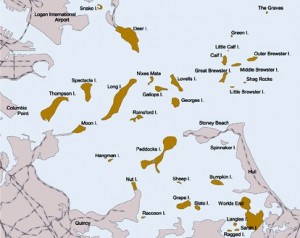
Map of Boston Harbor
Chris leans on the throttle… we’re past the no wake zone of the inner harbor. His Mako with 140 horses out back is anxious to cut loose. He keeps it just outside his condo at the Charleston Navy Yard. Now we’re headed out into the harbor, just off Logan, and jets descend on approach overhead. Lots of chop given strong winds. The Mako leaps and bounds in the rough waters. Ferries, sail boats, planes, cars on bridges (tunnels below)… the busy Boston harbor on a summer afternoon. Twice a week, LNG tankers are escorted in and out of the harbor. We see several large container ships plying the harbor.
Boston Harbor is an exceptional story of environmental clean-up. For many, many years, the Harbor was a mess, the cesspool for communities in its watershed. In the 1700s, illnesses broke out because of illegal dumping of animal parts and other garbage in its waters. By the 1970s the situation was out of hand, with a putrid stench often emanating from the harbor and into the downtown.
In 1984 a federal judge ruled that the region was in violation of the 1972 Clean Water Act and ordered Boston to build a secondary treatment plant for its sewage. This prompted a $3.8 billion investment at Deer Island wastewater treatment plant by the Massachusetts Water Resources Authority (MWRA), the second largest project of its kind in the nation (the largest in Chicago). MWRA also spent $850 million to control sewage overflows and to protect beaches and shell fishing.
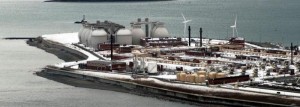
Deer Island wastewater treatment plant
Deer Island is actually not an island. It’s been a peninsula since 1938 when a hurricane filled the Shirley Gut Channel. Deer Island is visible from most harbor vantage points. Its 150-foot tall, egg-like sludge digesters are landmarks to this massive cleanup project. They became operational in 1995, with continual upgrades over the years to accommodate increased flows. The plant is able to treat more than a billion gallons of wastewater a day, with an eight-mile outfall to the depths of Massachusetts Bay. Now the harbor is swimmable, with eight miles of urban beaches. Lobstering is back. In 1996, the Boston harbor Islands was designated a National Recreation Area.
We pass “the eggs,” the sea is even rougher and the Mako pounds through the waves. Chris is in his element at the helm. I grip the center console. Boston Harbor is about 50 square miles in size and has 34 islands, most of which are now part of a preserve. Chris shows me some of the spots where he and his wife Ping take their sailboat, moor and camp, taking a dinghy ashore to explore.
Municipally-owned wind turbine in Hull
Long Island is 1.75 miles long; Spectacle Island is a capped landfill. There’s Civil War-era Fort Warren on Georges Island; the oldest lighthouse in the United States is on Little Brewster Island. Another was home to an asylum. A summer camp is accessible over a rickety bridge that we hear allows only one bus at a time. We pass under the massive iron bridge rising and rusting above us.
Chris points out Hull and its prominent 660 kW wind turbine. The City was first in the region to install a commercial-sized turbine in 2001. The municipal utility there partnered with the University of Massachusetts to develop the project at Windmill Point, a site used for two centuries to pump seawater into vats to produce salt. Rounding west, Chris points out the public beaches of South Boston.
North past busy wharfs. We pause as a cruise ship heads out to sea, then pass the federal courthouse at Fan Pier, and drop the Mako’s antenna to slip under Seaport Boulevard near the Tea Party Museum. We tie up dockside to the Barking Crab, then meet Wisner and Russ at the Daily Catch, buds from grade school. Calamari, beer, old memories, current life issues, my daughter Skye drops by to spice things up, and more. We boat back to Charleston, the fitting end to a New England summer adventure.